Web Ecologist

Web Ecologist

Wednesday, 09 June 2021 13:35

Swamp

A swamp is a forested wetland. Swamps are considered to be transition zones because both land and water play a role in creating this environment. Swamps vary in size and are located all around the world. The water of a swamp may be fresh water, brackish water, or seawater. Freshwater swamps form along large rivers or lakes where they are critically dependent upon rainwater and seasonal flooding to maintain natural water level fluctuations. Saltwater swamps are found along tropical and subtropical coastlines. Some swamps have hammocks, or dry-land protrusions, covered by aquatic vegetation, or vegetation that tolerates periodic inundation or soil saturation. The two main types of swamp are "true" or swamp forests and "transitional" or shrub swamps. In the boreal regions of Canada, the word swamp is colloquially used for what is more correctly termed a bog, fen, or muskeg. Some of the world's largest swamps are found along major rivers such as the Amazon, the Mississippi, and the Congo.


Source: Wikipedia contributors. "Swamp." Wikipedia, The Free Encyclopedia. Wikipedia, The Free Encyclopedia, 24 Jun. 2021. Web. 28 Jun. 2021.

Wednesday, 09 June 2021 13:35

Riparian zone

A riparian zone or riparian area is the interface between land and a river or stream. Riparian is also the proper nomenclature for one of the terrestrial biomes of the Earth. Plant habitats and communities along the river margins and banks are called riparian vegetation, characterized by hydrophilic plants. Riparian zones are important in ecology, environmental resource management, and civil engineering because of their role in soil conservation, their habitat biodiversity, and the influence they have on fauna and aquatic ecosystems, including grasslands, woodlands, wetlands, or even non-vegetative areas. In some regions, the terms riparian woodland, riparian forest, riparian buffer zone, riparian corridor, and riparian strip are used to characterize a riparian zone. The word riparian is derived from Latin ripa, meaning "river bank".

Characteristics

Riparian zones may be natural or engineered for soil stabilization or restoration. These zones are important natural biofilters, protecting aquatic environments from excessive sedimentation, polluted surface runoff, and erosion. They supply shelter and food for many aquatic animals and shade that limits stream temperature change. When riparian zones are damaged by construction, agriculture or silviculture, biological restoration can take place, usually by human intervention in erosion control and revegetation. If the area adjacent to a watercourse has standing water or saturated soil for as long as a season, it is normally termed a wetland because of its hydric soil characteristics. Because of their prominent role in supporting a diversity of species, riparian zones are often the subject of national protection in a biodiversity action plan. These are also known as a "plant or vegetation waste buffer".

Research shows that riparian zones are instrumental in water quality improvement for both surface runoff and water flowing into streams through subsurface or groundwater flow. Riparian zones can play a role in lowering nitrate contamination in surface runoff, such as manure and other fertilizers from agricultural fields, that would otherwise damage ecosystems and human health. Particularly, the attenuation of nitrate or denitrification of the nitrates from fertilizer in this buffer zone is important. The use of wetland riparian zones shows a particularly high rate of removal of nitrate entering a stream and thus has a place in agricultural management. Also in terms of carbon transport from terrestrial ecosystems to aquatic ecosystems, riparian groundwater can play an important role. As such, a distinction can be made between parts of the riparian zone that connect large parts of the landscape to streams, and riparian areas with more local groundwater contributions.


Source: Wikipedia contributors. "Riparian zone." Wikipedia, The Free Encyclopedia. Wikipedia, The Free Encyclopedia, 12 Jun. 2021. Web. 28 Jun. 2021.

Wednesday, 09 June 2021 13:35

River

A river is a natural flowing watercourse, usually freshwater, flowing towards an ocean, sea, lake or another river. In some cases, a river flows into the ground and becomes dry at the end of its course without reaching another body of water. Small rivers can be referred to using names such as stream, creek, brook, rivulet, and rill. There are no official definitions for the generic term river as applied to geographic features, although in some countries or communities a stream is defined by its size. Many names for small rivers are specific to geographic location; examples are "run" in some parts of the United States, "burn" in Scotland and northeast England, and "beck" in northern England. Sometimes a river is defined as being larger than a creek, but not always: the language is vague.

Melting toe of Athabasca Glacier, Jasper National Park, Alberta, Canada
Rivers are part of the hydrological cycle. Water generally collects in a river from precipitation through a drainage basin from surface runoff and other sources such as groundwater recharge, springs, and the release of stored water in natural ice and snowpacks (e.g., from glaciers).

Rivers and streams are often considered major features within a landscape; however, they actually only cover around 0.1% of the land on Earth. They are made more obvious and significant to humans by the fact that many human cities and civilizations are built around the freshwater supplied by rivers and streams.Most of the major cities of the world are situated on the banks of rivers, as they are, or were, used as a source of water, for obtaining food, for transport, as borders, as a defensive measure, as a source of hydropower to drive machinery, for bathing, and as a means of disposing of waste.

Potamology is the scientific study of rivers, while limnology is the study of inland waters in general.


Source: Wikipedia contributors. "River." Wikipedia, The Free Encyclopedia. Wikipedia, The Free Encyclopedia, 8 Jun. 2021. Web. 28 Jun. 2021.

Wednesday, 09 June 2021 13:35

Stream

A stream is a body of water with surface water flowing within the bed and banks of a channel. The flow of a stream is controlled by three inputs – surface water, subsurface water and groundwater. The surface and subsurface water are highly variable between periods of rainfall. Groundwater, on the other hand, has a relatively constant input and is controlled more by long-term patterns of precipitation. The stream encompasses surface, subsurface and groundwater fluxes that respond to geological, geomorphological, hydrological and biotic controls.

Depending on its location or certain characteristics, a stream may be referred to by a variety of local or regional names. Long large streams are usually called rivers.

Streams are important as conduits in the water cycle, instruments in groundwater recharge, and corridors for fish and wildlife migration. The biological habitat in the immediate vicinity of a stream is called a riparian zone. Given the status of the ongoing Holocene extinction, streams play an important corridor role in connecting fragmented habitats and thus in conserving biodiversity. The study of streams and waterways in general is known as surface hydrology and is a core element of environmental geography.


Source: Wikipedia contributors. "Stream." Wikipedia, The Free Encyclopedia. Wikipedia, The Free Encyclopedia, 3 Jun. 2021. Web. 28 Jun. 2021.


Wednesday, 09 June 2021 12:36

Lake

A lake is an area filled with water, localized in a basin, surrounded by land, apart from any river or other outlet that serves to feed or drain the lake. Lakes lie on land and are not part of the ocean, although like the much larger oceans, they form part of earth's water cycle. Lakes are distinct from lagoons which are generally coastal parts of the ocean. They are generally larger and deeper than ponds, which also lie on land, though there are no official or scientific definitions. Lakes can be contrasted with rivers or streams, which are usually flowing in a channel on land. Most lakes are fed and drained by rivers and streams.

Natural lakes are generally found in mountainous areas, rift zones, and areas with ongoing glaciation. Other lakes are found in endorheic basins or along the courses of mature rivers, where a river channel has widened into a basin. In some parts of the world there are many lakes because of chaotic drainage patterns left over from the last Ice Age. All lakes are temporary over geologic time scales, as they will slowly fill in with sediments or spill out of the basin containing them.

Many lakes are artificial and are constructed for industrial or agricultural use, for hydro-electric power generation or domestic water supply, or for aesthetic, recreational purposes, or other activities.

Source: Wikipedia contributors. "Lake." Wikipedia, The Free Encyclopedia. Wikipedia, The Free Encyclopedia, 23 Jun. 2021. Web. 28 Jun. 2021.

Wednesday, 09 June 2021 12:36

Pond

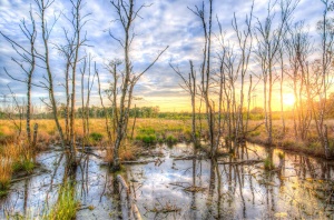
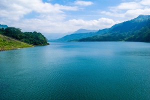
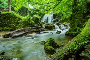
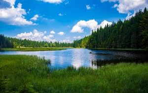
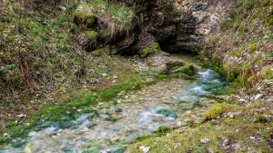
A pond is an area filled with water, either natural or artificial, that is smaller than a lake. Ponds may arise naturally in floodplains as part of a river system or can simply be an isolated depression (such as a kettle, vernal pool, or prairie pothole) that filled with runoff, groundwater, or precipitation. As such, ponds may be freshwater, saltwater, or brackish in nature.

Many ponds contain shallow water ecosystems, often termed pond life, with varying abundances of aquatic plants and animals. Certain characteristic such as depth, seasonal water level, nutrients fluxes, solar radiation, degree of inlets and outlets, local organisms, and salinity may affect the types of ecosystems present within a pond.

Ponds are frequently man-made or expanded beyond their original depths and bounds by anthropogenic causes. Among their many uses, ponds provide water for agriculture, livestock and communities, aid in habitat restoration, serve as breeding grounds for local and migrating species, are components of landscape architecture, flood control, general urbanization, mitigate particular pollutions and greenhouse gasses, and support wide varieties of organismal ecosystems.

Pond Biodiversity

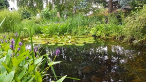
A defining feature of a pond is the presence of standing water which provides habitat for a biological community commonly referred to as pond life. Because of this, many ponds and lakes contain large numbers of endemic species that have gone through adaptive radiation to become specialized to their preferred habitat. Familiar examples might include water lilies and other aquatic plants, frogs, turtles, and fish.

Common freshwater fish species include the Large Mouth and Small Mouth Bass, Catfish, Bluegill, and Sunfish such as the Pumpkinseed Sunfish shown above
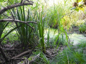
Often, the entire margin of the pond is fringed by wetland, and these wetlands support the aquatic food web, provide shelter for wildlife, and stabilize the shore of the pond. This margin is also known as the littoral zone and contains much of the photosynthetic algae and plants of this ecosystem called macrophytes. Other photosynthetic organisms such as phytoplankton (suspended algae) and periphytons (organisms including cyanobacteria, detritus, and other microbes) thrive here and stand as the primary producers of pond food webs. Some grazing animals like geese and muskrats consume the wetland plants directly as a source of food. In many other cases, pond plants will decay in the water. Many invertebrates and herbivorous zooplankton then feed on the decaying plants, and these lower trophic level organisms provide food for wetland species including fish, dragonflies, and herons both in the littoral zone and the limnetic zone. The open water limnetic zone may allow algae to grow as sunlight still penetrates here. These algae may support yet another food web that includes aquatic insects and other small fish species. A pond, therefore, may have combinations of three different food webs, one based on larger plants, one based upon decayed plants, and one based upon algae and their specific upper trophic level consumers and predators. Hence, ponds often have many different animal species using the wide array of food sources though biotic interaction. They, therefore, provide an important source of biological diversity in landscapes.

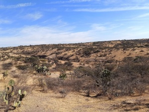
Opposite to long standing ponds are vernal ponds. These ponds dry up for part of the year and are so called because they are typically at their peak depth in the spring (the meaning of "vernal" comes form the Latin word for spring). Naturally occurring vernal ponds do not usually have fish, a major higher tropic level consumer, as these ponds frequently dry up. The absence of fish is a very important characteristic of these ponds since it prevents long chained biotic interactions from establishing. Ponds without these competitive predation pressures provides breeding locations and safe havens for endangered or migrating species. Hence, introducing fish to a pond can have seriously detrimental consequences. In some parts of the world, such as California, the vernal ponds have rare and endangered plant species. On the coastal plain, they provide habitat for endangered frogs such as the Mississippi Gopher Frog.

Source: Wikipedia contributors. "Pond." Wikipedia, The Free Encyclopedia. Wikipedia, The Free Encyclopedia, 27 Jun. 2021. Web. 28 Jun. 2021.

Wednesday, 09 June 2021 12:35

Spring

A spring is a point at which water flows from an aquifer to the Earth's surface. It is a component of the hydrosphere.

A spring may be the result of karst topography where surface water has infiltrated the Earth's surface (recharge area), becoming part of the area groundwater. The groundwater then travels through a network of cracks and fissures—openings ranging from intergranular spaces to large caves. The water eventually emerges from below the surface, in the form of a karst spring.

The forcing of the spring to the surface can be the result of a confined aquifer in which the recharge area of the spring water table rests at a higher elevation than that of the outlet. Spring water forced to the surface by elevated sources are artesian wells. This is possible even if the outlet is in the form of a 300-foot-deep (91 m) cave. In this case the cave is used like a hose by the higher elevated recharge area of groundwater to exit through the lower elevation opening.

Non-artesian springs may simply flow from a higher elevation through the earth to a lower elevation and exit in the form of a spring, using the ground like a drainage pipe.

Still other springs are the result of pressure from an underground source in the earth, in the form of volcanic activity. The result can be water at elevated temperature such as a hot spring.

The action of the groundwater continually dissolves permeable bedrock such as limestone and dolomite, creating vast cave systems.

Types

  • Depression springs occur along a depression, such as the bottom of alluvial valleys, basins, or valleys made of highly permeable materials.
  • Contact springs, which occur along the side of a hill or mountain, are created when the groundwater is underlaid by an impermeable layer of rock or soil known as an aquiclude or aquifuge
  • Fracture, joint, or tubular springs occur when groundwater running along an impermeable layer of rock meets a crack (fracture) or joint in the rock.
  • Artesian springs typically occur at the lowest point in a given area. An artesian spring is created when the pressure for the groundwater becomes greater than the pressure from the atmosphere. In this case the water is pushed straight up out of the ground.
  • Wonky holes are freshwater submarine exit points for coral and sediment-covered, sediment-filled old river channels.
  • Karst spring
  • Hot springs, which have a water temperature significantly higher than the mean air temperature of the surrounding area.

Source: Wikipedia contributors. "Spring (hydrology)." Wikipedia, The Free Encyclopedia. Wikipedia, The Free Encyclopedia, 17 Jun. 2021. Web. 28 Jun. 2021.

Wednesday, 09 June 2021 12:34

Cold desert

Cold deserts, sometimes known as temperate deserts, occur at higher latitudes than hot deserts, and the aridity is caused by the dryness of the air. Some cold deserts are far from the ocean and others are separated by mountain ranges from the sea, and in both cases, there is insufficient moisture in the air to cause much precipitation. The largest of these deserts are found in Central Asia. Others occur on the eastern side of the Rocky Mountains, the eastern side of the southern Andes and in southern Australia. Polar deserts are a particular class of cold desert. The air is very cold and carries little moisture so little precipitation occurs and what does fall, usually snow, is carried along in the often strong wind and may form blizzards, drifts and dunes similar to those caused by dust and sand in other desert regions. In Antarctica, for example, the annual precipitation is about 50 mm (2 in) on the central plateau and some ten times that amount on some major peninsulas.


Source: Wikipedia contributors. "Desert." Wikipedia, The Free Encyclopedia. Wikipedia, The Free Encyclopedia, 14 Jun. 2021. Web. 28 Jun. 2021.


Wednesday, 09 June 2021 12:34

Xeric vegetation

Deserts and xeric shrublands are a biome defined by the World Wide Fund for Nature. Deserts and xeric (ancient Greek xērós, “dry") shrublands form the largest terrestrial biome, covering 19% of Earth's land surface area. Ecoregions in this habitat type vary greatly in the amount of annual rainfall they receive, usually less than 250 millimetres (10 in) annually except in the margins. Generally evaporation exceeds rainfall in these ecoregions. Temperature variability is also diverse in these lands. Many deserts, such as the Sahara, are hot year-round, but others, such as East Asia's Gobi, become quite cold in winter.

Temperature extremes are a characteristic of most deserts. High daytime temperatures give way to cold nights because there is no insulation provided by humidity and cloud cover. The diversity of climatic conditions, though quite harsh, supports a rich array of habitats. Many of these habitats are ephemeral in nature, reflecting the paucity and seasonality of available water. Woody-stemmed shrubs and plants characterize vegetation in these regions. Above all, these plants have evolved to minimize water loss. Animal biodiversity is equally well adapted and quite diverse.


Source: Wikipedia contributors. "Deserts and xeric shrublands." Wikipedia, The Free Encyclopedia. Wikipedia, The Free Encyclopedia, 10 May. 2021. Web. 28 Jun. 2021.

Wednesday, 09 June 2021 12:34

Dune

A dune is a landform composed of wind- or water-driven sand. It typically takes the form of a mound, ridge, or hill. An area with dunes is called a dune system or a dune complex. A large dune complex is called a dune field, while broad, flat regions covered with wind-swept sand or dunes with little or no vegetation are called ergs or sand seas. Dunes occur in different shapes and sizes, but most kinds of dunes are longer on the stoss (upflow) side, where the sand is pushed up the dune, and have a shorter slip face in the lee side. The valley or trough between dunes is called a dune slack.

Dunes are most common in desert environments, where the lack of moisture hinders the growth of vegetation that would otherwise interfere with the development of dunes. However, sand deposits are not restricted to deserts, and dunes are also found along sea shores, along streams in semiarid climates, in areas of glacial outwash, and in other areas where poorly cemented sandstone bedrock disintegrates to produce an ample supply of loose sand. Subaqueous dunes can form from the action of water flow (fluvial processes) on sand or gravel beds of rivers, estuaries, and the sea-bed.

Some coastal areas have one or more sets of dunes running parallel to the shoreline directly inland from the beach. In most cases, the dunes are important in protecting the land against potential ravages by storm waves from the sea. Artificial dunes are sometimes constructed to protect coastal areas. The dynamic action of wind and water can sometimes cause dunes to drift, which can have serious consequences. For example, the town of Eucla, Western Australia, had to be relocated in the 1890s because of dune drift.

Conservation

Dune habitats provide niches for highly specialized plants and animals, including numerous rare species and some endangered species. Due to widespread human population expansion, dunes face destruction through land development and recreational usages, as well as alteration to prevent the encroachment of sand onto inhabited areas. Some countries, notably the United States, Australia, Canada, New Zealand, the United Kingdom, Netherlands, and Sri Lanka have developed significant programs of dune protection through the use of sand dune stabilization. In the U.K., a Biodiversity Action Plan has been developed to assess dunes loss and to prevent future dunes destruction.


Source: Wikipedia contributors. "Dune." Wikipedia, The Free Encyclopedia. Wikipedia, The Free Encyclopedia, 23 Jun. 2021. Web. 28 Jun. 2021.


Page 2595 of 3231

NatureSpots NSP AppScreens 06 S9 Trans

Hey, do you love Nature?

Observing and learning about nature is fun and can help to protect our environment. In the NatureSpots App, you can put up all kinds of nature sightings - from species to habitats. Join up and help to build a biodiversity data set and share your photos!

JOIN THE COMMUNITY

Create your account or download the NatureSpots App for your Smartphone now to join the community!

NatureSpots App with plants and leaves

Get the free App!

NatureSpots is a non-profit and 100% community-driven project. We run it because we love to discover our world and share our findings with others. The app does not contain any ads and we do not get money from this project at all. Download the App on your Smartphone and join up!

Android AppStoreBadge 150x45px IOS AppStoreBadge 150x45px

Want to partner up for a new biodiversity experience?

We are looking for partners, who are interested in biodiversity data, Citizen Science and being part of a modern and unique app. NatureSpots App is running on the SPOTTERON Citizen Science platform and provides a wide range of interactive features. For partners, we can provide communication tools, access to the data administration interface and download of occurrence records without any costs.

Please get in contact via office@spotteron.net if you are interested in joining NatureSpots with your organization! Let's talk about the future of biodiversity monitoring and how we can work best together!